post

South Dempster Highway

August 5, 2025 – Tombstone – Dempster Highway from Dawson City, Yukon

2025 Yukon & Northwest Territories

Tombstone & Oglivie Mountains – South Dempster Hwy

As we drive to the start of the Dempster Highway, our local guide shares that the Klondike Highway to Dawson was built in 1953. Previously, traffic between Whitehorse and Dawson City used river boats during warm weather and a wagon road was used in winter. As we cross the Klondike River bridge and start our journey north on the Dempster Highway, she tells us the story of The Lost Patrol – the ill-fated mission to Fort McPherson by an experienced North West Mounted Police dog sled team that lost their way in the winter of 1911. All froze to death on this very route we are on.

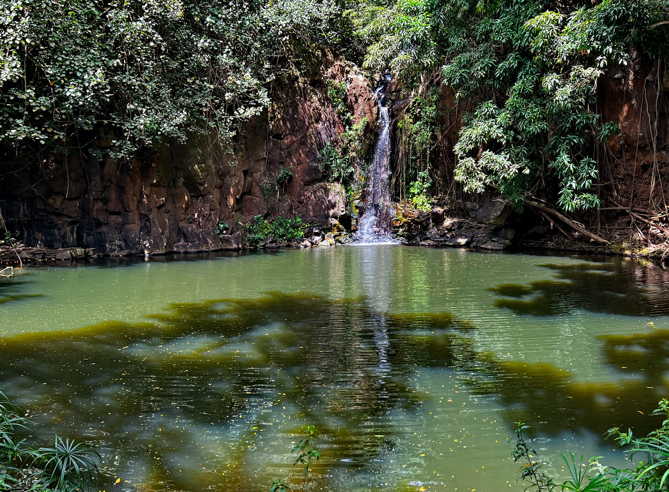
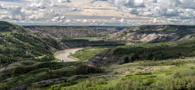
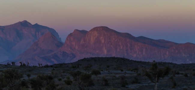
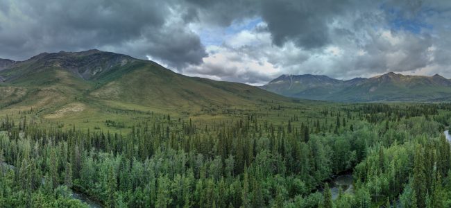
This southern section of the gravel, all-season Dempster Highway follows the North Klondike River, however the highway continues all the way to Inuvik and onward to Tuktoyaktuk in the North West Territories. Legends are shared about pioneers Joe and Annie Henry, who lived at Wolf Creek, which is in the area we drive through today. The Oglivie Mountains are spectacular in the summer light along this route. By noon we arrive at the Tombstone Territorial Interpretive Centre and Campground, where we have a rest break and a picnic lunch. I pop my drone up to capture some panoramas and video of this beautiful area.

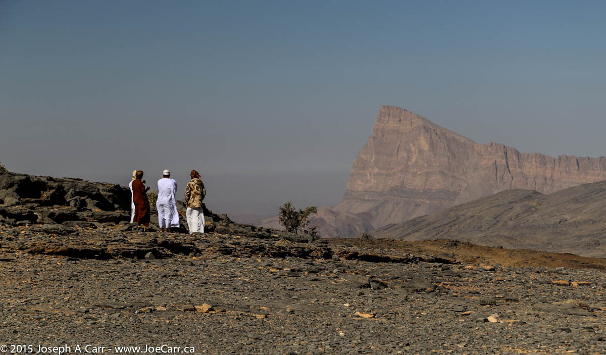
After lunch, we continue north through the beautiful Blackstone Valley, arriving at Two Moose Lake at 1:30pm, the most northerly point in our drive today. On our return drive south, we stop at the Tombstone Mountain lookout, where we catch glimpses of that iconic mountain to the south through the heavy clouds. We continue south, arriving back in Dawson City in the late afternoon. Despite the overcast skies and a few rain showers, it was great to experience “The Dempster” as this route is referred to by locals. Our bus is covered in mud from this gravel highway, so our driver has to make a trip to the local vehicle wash!

Dawson City

I have drinks and dinner with a couple from our tour group this evening. We start at Bombay Peggy’s for Naughty martinis: Midnight Cowboy (cacao & espresso), Bloomer Remover (classic gin martini) for me, and a Big Speak (cranberry). Although expensive, all three cocktails meet our exacting standards in this funky bar with a history! We decide on the Drunken Goat Taverna – Greek Couzina for dinner. We sat with others from our group as we enjoyed the tasty food on the street-side patio.

Joe with 3 martinis
post

Whitehorse to Dawson

July 31, 2025 – Whitehorse to Dawson City, Yukon

2025 Yukon & Northwest Territories

I have a substantial breakfast this morning and grab a muffin for our long road trip to Dawson City on the Klondike Highway 2. We leave at 8:10am without one couple and our tour director. Alastair is staying with the couple until the man who is suffering a medical incident is transported to hospital. He will then fly to Dawson to catch up with the group, so our bus driver Harold will lead the group today. We see new housing developments as we leave Whitehorse: new subdivisions, schools, commercial buildings and roads are being built in Whitehorse.

Points of interest on the road trip

  • Lake Laberge – I catch a glimpse of this famous lake (The Cremation of Sam McGee – Robert Service) through the bus window
  • Fox Lake – a long lake parallel to the highway
  • Braeburn Lodge – our first rest stop, where giant cinnamon buns are sold for $20 each! There is an airstrip on the other side of the highway.
  • Montague Road House – a rest stop which was part of the overland trail between Whitehorse and Dawson City

  • Carmacks – a rest stop with a general store, gas station, hotel and restaurant, where the highway crosses the Yukon River
  • Five Fingers Rapid – some members of the group hike down the steep stairs and trail to the rapids. I stay at the observation platform to fly my drone, capturing some panoramic photos and video of the river, valley and rapids.
  • Minto Landing RV – we stop for lunch by the river at this new RV park, which is still being developed. Our driver Harold is conscripted to serve the soup!
  • Pelly River Crossing – a rest stop with a general store and gas station, and 5G mobile reception! The highway is no longer following the Yukon River.
  • Stewart Crossing – a rest stop where the highway is now following the Stewart River.
  • Gravel Lake – rest stop where the highway is on the southern side of a broad valley. The Tintina Fault runs through this area of the Yukon from Circle, Alaska to Watson Lake.
The Tintina Fault runs from Circle, Alaska to Watson Lake, Yukon. The SW corner of Yukon landmass shifted 1,000 km 55 million years ago. Yukon government information sign at Gravel Lake.

We are staying at the Triple J Hotel and Cabins in Dawson City. I join some other tour group members for dinner and a beer in the hotel restaurant. Despite being a modest establishment, the food and service are good. After dinner, I go for a walking tour of historic Dawson City, since it is still daylight at 11PM!

post

Rainforest Hike – Manoa Valley

2023 Vancouver-Hawai’i Cruise

Oct 18, 2023 – Day 2 in Honolulu – Rainforest Hike in the Manoa Valley

I have breakfast in the Main Dining Room this morning: cappuccino, Passion fruit parfait, and a smoked salmon omelet. Afterward, I grab my notebook computer and go to the Crow’s Nest to hang out there. At 9:30AM the Pacific Collector, a US Navy Auxiliary ship is pushed into an adjacent dock by two tugs. It doesn’t appear to be under power, and has two large white domes on the main cargo deck.

Pacific Collector being towed into the harbour and docked

I go on an excursion today: Tropical Rain Forest Nature Walk. It is leaves at 11:45AM, including a 45 minute hike through the Lyon Arboretum rain forest in the Valley of the Rainbows at the head of the beautiful Manoa Valley. I take lots of photos of the many plants, flowers and birds found in the rain forest. Our guide then drives us to the Pu’u Uala’kaa — the hill of the rolling sweet potatoes above the city at an elevation of 1,048 feet. We have great views of Diamond Head, Waikiki, Honolulu, and the harbour and airport, and our ship is visible from here. We also drive through Punchbowl Crater, which is a memorial graveyard for the US Armed Services.

We return to the ship just after 3PM, well before the 4:30 All Aboard time. After getting cleaned up, I decide to wear my new Aloha shirt from our port call in Kaua’i.

4:30PM Captain’s Report – We will sail between two low pressure systems on the return voyage to Vancouver. Waves are expected to be 10′ most of the way, as both systems are generating significant wave action. Koningsdam was scheduled to depart Honolulu at 5PM, but it looks like we will be delayed by an hour due to a medical disembarkation and some late-arriving passengers from an excursion.

Our delayed departure actually works out really well, since the ship sails out of the harbour entrance at sunset, giving us beautiful views along the coastline with some dramatic clouds, ships in the distance on the horizon, all making for some good photos. After looking closer at my sunset photos, I realize there are five mirages of ships and the city floating above the ocean!

post

Kaua’i

Oct 18, 2022 – South Shore, Kaua’i, Hawai’i, USA

2022 Hawai’i cruise

My excursion to the Allerton and McBryde Tropical Gardens doesn’t leave until 9:00AM, so it’s an easy start to the day. I get up around 7:30AM and go down to the Grand Dutch Cafe for a breakfast of smoked salmon, raisin bun, blueberry muffin and a cappuccino. I show up in the pier building ashore around 8:45AM and we are quickly organized into a line. Once the last two people arrive, we’re off in the excursion shuttle, but not before one man refuses to wear a mask, so our guide reads the riot act to him and he eventually puts a mask on. Our guide reveals that the ship let them know that there is some sickness onboard, so they are requiring masks for our group when in their shuttles.

Once that is sorted out, we drive to the gardens site, which takes the better part of an hour since the road into the property is quite rough, requiring slow going. It’s a beautiful area of the south shore of Kaua’i which I haven’t experienced before. The number of plants in the McBryde Garden is endless: 6,000 rare and endangered plant species collected from throughout the Pacific Basin and the world. The Allerton Garden is architecturally designed with outside ‘rooms’ which the Allertons originally used for entertaining guests – some rich and famous like Jackie Kennedy-Onassis. We have a nice lunch at the snack bar consisting of shredded chicken or shrimp with focaccia bread, potato salad, and soft drinks or bottled water. 

Spouting Horn blowhole, Koloa, Kaua'i, Hawaii
Spouting Horn blowhole, Koloa, Kaua’i, Hawaii

After lunch, we visit the waterfall in the McBryde property by driving deeper into the upper Lawai Valley, and then leave to return to the ship. We encounter a firetruck and ambulance doing a rescue on the way out of the Allerton and McBryde property, which delays us a bit while our guide sorts out passing the emergency vehicles on the narrow road. We make a quick stop at the Spouting Horn blowhole, which is putting on a good show today. All Aboard is 2:30PM, and we are the last to board with only five minutes to spare!

I go up to the Sun Deck to enjoy the sail away from Nawiliwili Harbour, and I have a beer with some friends while watching our ship maneuver out the narrow passage, taking a time lapse video handheld. Once the ship is in open water heading for Vancouver, I return to my stateroom to get cleaned up, and then I have a quick dinner in the Lido this evening: Beef Sukiyaki over fried rice, which is quite filling and delicious.

Sailaway from Kaua'i - Koningsdam departs
Sailaway from Kaua’i – Koningsdam departs

At 8PM I attend The Step One Dance Company Presents: Humanity Reprise. I thought it would be a different show than the one I already attended on our sea days to Hawaii, but it is exactly the same, which was disappointing. Our cruise director takes the stage ahead of the performance to make some announcements about upcoming events and activities, and to let us know that the ship’s time will change overnight (clock moves forward an hour). Some crank of a man yells at him from the audience as he is leaving the stage that he should be letting everyone know there is COVID-19 aboard the ship. He briefly stops, but he doesn’t respond and vanishes backstage.

I walk the Promenade Deck this evening for a circuit and a half, enjoying the warm, tropical air and the sound of the ship. I then go up to the Crow’s Nest Lounge for my nightcap of a Tanqueray 10 classic martini as I annotate today’s photos. I remove the Jethro Mobile SIM from my iPhone, which I’ve been using for voice calling and data in Hawai’i, since I won’t need that mobile service again. It worked very well, was reasonably priced at CA$35 prepaid on Amazon for 4Gb and unlimited calling for 30 days. I would buy service from them again when I travel to the USA in future. 

post

Alberta Badlands

July 2, 2018 Monday – Cretaceous/Tertiary Boundary and Tyrrell Museum Badlands, Alberta, Canada

Victoria to Calgary road trip 2018

After having an early breakfast in my hotel room, our tour bus leaves by 8AM. Our all-day tour hosts are both geologists (and RASC members), so they share lots of info about rocks, glaciation, the K/T Boundary, and how the dinosaurs died off so quickly 65 million years ago. We are all given handouts authored by our hosts, with scientific  references, diagrams, and notes.

JoeTourist: Dry Island Buffalo Jump Park &emdash; The group expores a ridgeline for the K/T Boundary

Our first stop is Dry Island Buffalo Jump Park, where we dig around a bit and see the K/T Boundary for ourselves. There are hoodoos, piles of lignite, and a beautiful valley with the Red River below.  The park gets its name from a “dry island” formed by the ancient flow of the Red River, and later used by First Nations people as they drove buffalo over the cliff edge to their deaths, ensuring everyone survived the winter. This park is accessible during fair-weather and daytime only, but it is a fascinating area to explore!

JoeTourist: Royal Tyrrell Museum &emdash; Stegosaurus fossil

Our next stop is the Royal Tyrrell Museum in Drumheller. I have visited this museum before, but it is one of those museums where you can go back again and again to see and learn about new things. Today is the Canada Day civic holiday, so it is crowded, but as a tour group we have priority admission arranged, so walk right in ahead of the lines. There are dinosaurs on display here that defy description, along with all the usual suspects like Tyrannosaurus rex, Triceratops, Brontosaurus, Stegosaurus, fish, turtles, shellfish, worms, you name it! All the fossils are from this area of Alberta, which is rich in fossilized remains from this epoch.

JoeTourist: Trekcetera &emdash; Star Trek artifacts

Our last stop is a complete change of pace: the Trekcetera Museum (since closed), also located in Drumheller. Their main claim to fame is the amazing collection of all things to do with Star Trek: phasers, hollow decks, original costumes, and other original memorabilia from the Trek movies and TV series. They also cover Men In Black, Superman, Titanic, Sherlock Holmes, and other entertainment classics. This little museum appealed to those of us who are Trekkies!

After a full day of touring, a few of us walk from the hotel to nearby Gus’s Cafe and Pizzeria for dinner. The food is good, but the service is surly, just like the online reviews indicated!

post

Jebel Shams to Muscat

February 21, 2015 – Saturday – Jebel Shams to Muscat

2015 Gems of Arabia

JoeTourist: Jebel Akhdar &emdash; Beehive tombs on the ridgeline
Beehive tombs on the ridgeline at Al Ayn

After driving down the steep roads from Jebel Shams, we visit the beehive tombs at Al Ayn.These tombs are about 5,000 years old, although not much is known about them. This means the necropolises were built in the same era as the Egyptian pyramids. The tombs are fascinating and quite photogenic, however as we descend from the ridge to return to our 4x4s, the wind picks up and a sand storm blasts everyone as we hurry to get back inside our vehicles.

Next stop is Jabrin Castle, which was built by the Yaruba dynasty Imam Bil’arab bin Sultan, who ruled from 1679 to 1692. This is without a doubt the most impressive castle or fortification we have visited in Oman. It is a UNESCO World Heritage Site, is beautifully restored, and is surrounded by groves of palm trees in a lush valley. The castle has impressive wooden painted ceilings in some rooms.

After driving back along the highway to Muscat, we say goodbye to our driver Ali, who drops us off at the City Seasons Hotel. He has been an excellent driver; taking us over sand dunes at Sharqiya Sands, along back roads to Bedouin camps, and zooming up and down both expressways and mountain roads. It has been a wonderful driving adventure in our 4x4s over the last five days. Tomorrow, we return to Dubai by bus for our final day in Arabia before returning home.

post

Jebel Shams

February 20, 2015 – Friday – Nizwa to Jebel Shams

2015 Gems of Arabia

Omani man eating some dates - lunch stop, Al Hamra oasis
Omani man eating some dates – lunch stop, Al Hamra oasis

After leaving our palatial hotel in Nizwa, we stop for lunch in the Al Hamra oasis, and make a brief stop to see the abandoned Persian village of Ghul before climbing 2,000 metres up into the mountains. Our destination is Jebel Shams (Mountain of the Sun),  Oman’s highest mountain at 3,028 metres (just over 10,000 feet). We stay at the Jebel Shams Resort, which is at the end of a long, winding and steep road. The resort is situated a few hundred metres from Wadi Ghul, the Grand Canyon of Arabia.

I walk over from the resort to the rim of the canyon before dinner, and find a spectacular sight that is much deeper than the Grand Canyon in Arizona. I peer over the edge of Wadi Ghul to a small abandoned village barely visible almost 1,000 metres below! The wind is terribly strong, but at least it is blowing up the canyon and over the rim, so it isn’t a safety hazard. I find taking photos of the canyon in the late afternoon very challenging, and resort to bracketed photos and HDR settings.

Jebel Shams Resort has pretty basic accommodation compared to the luxury we have had so far on the tour. I keep the electric heater going in my room, since at this elevation, it gets very cold at night. The Internet connection is down, so I use my time this evening to catch up on my journal and tag my photos with locations and titles.

February 21, 2015 – Jebel Shams to Muscat

I get up before dawn this morning and take some photos of the mountains bathed in the pre-dawn light. The pre-dawn view of the mountains, the Earth’s shadow and the Belt of Venus is spectacular! After an early breakfast, we drive (as a group) the short distance from the resort to see and photograph Wadi Ghul after sunrise, and then drive down the mountain and onto the wadi and other sights before returning to Muscat and civilization.

post

Nizwa

February 20, 2015 – Friday – Nizwa to Jebel Shams

2015 Gems of Arabia

It is another full day today, beginning with a visit to yet another souq: the Nizwa Souq. This souq is perhaps the most interesting of them all, since it is huge, and offers an amazing variety: cattle and goat market, butchered meat, fruit and vegetables, silver jewelry (especially silver khanjars – traditional daggers of Oman) and crafts. The Halwa shop (Omani sweets) is undoubtedly the busiest place in the whole souq. However, there are no camels at this livestock sale. In addition to the large number of locals, there are lots of tourists at the souq…and everyone arrives early!

I have lots of time to people watch, and yet I see only one woman the whole time I’m there. Omani men (and their sons) are doing the shopping, at least at the souq. Nizwa’s fort is on the edge of the souq. It was built in the 17th century, and dominates the city with a 40 metre (125 foot) high huge round tower. I walk the back streets to see where the residents live. It is considerably quieter away from the souq, and the city appears to be very well developed, and offers its residents a good quality of life.

The oasis at Al Hamra

After leaving the souq, we visit the oasis village of Al Hamra, at the foot of the Hajar Mountains. This village is one of the oldest in Oman, and has a well-preserved row of two- and three-story mud-brick houses built in the old Yemeni style. We visit a traditional Omani house (Beit al-Safa) and have lunch in the oasis.

After leaving the oasis, we climb 2,000 metres up the tallest mountain in Oman, Jebel Shams. We are staying at Jebel Shams Resort, situated across the road from Wadi Ghul, the Grand Canyon of Arabia.

Map of our 4x4 drives in Oman,
Map of our 4×4 drives in Oman,
post

Muscat to Sharqiya Sands

February 17, 2015 – Tuesday – Muscat to Sharqiya Sands

2015 Gems of Arabia

Map of our 4x4 drives in Oman,
Map of our 4×4 drives in Oman,

We drive from Muscat along a new inland road to our first stop to see a large sink hole, where some people are swimming – Bimmah Sinkhole is in Muntazah Hawit Najam Park. This otherwise sun parched area obviously has water below ground, since there is vegetation here and I even spot some birds.

Our next stop is Wadi Tiwi, which is a lush river valley just a short distance from the coastline. The plantations and a string of emerald-coloured pools in the narrow valley are especially beautiful as we walk along the narrow road, which winds up the valley from village to village.

We stop for lunch in the sleepy little seaside town of Sur. There is a wonderful view across Sur’s corniche, beach and fisherman’s boats to the nearby village of Ayjah, with its whitewashed houses and dhow-building yard (see banner image above).

Desert Nights Camp at sunrise - Sharqiya Sands
Desert Nights Camp at sunrise – Sharqiya Sands

A couple of hours later we approach the small town of Bidiyah, where we turn off the main road to drive across a sand road for about 11km to Desert Nights Camp, where we stay for two nights.

It is pretty luxurious considering it is setup in the desert along with another more modest camp about a kilometre away. Sharqiya Sands (aka Wahiba Sands) is a large area of rosy-hued dunes, some of which are over 100 metres high. We quickly get settled and then go out on a dune ride to see the sun set over the sand dunes.

post

Muscat

2015 Gems of Arabia

February 15, 2015 – Sunday – Khasab to Muscat

Dessert buffet at the City Seasons Hotel

After our flight lands in Muscat, we meet our Omani guide Yacoob, who will be with us until we leave Oman. The bus takes us to the City Seasons Hotel in the city, where we have the afternoon to ourselves. I catch up on my travel journal and photos, and have a nap this afternoon. We have a sumptuous and extensive dinner buffet in the hotel, consisting of western, Indian, and Omani food. Table service is top notch, and the desserts are amazing! The Al-Zawawi Mosque is nearby and is beautifully lit at night, so several of us find a good vantage point to take photos.

February 16, 2015 – Monday – Muscat

This morning we visit the Sultan Qaboos Grand Mosque: a beautiful example of Islamic architecture with exquisite crystal chandeliers, stained glass windows, wonderful flower gardens, and a beautiful exterior design. Arriving early means we are ahead of the cruise ship tours, so it’s nice to have lots of room and few crowds for the first 45 minutes. The whole experience at the mosque is peaceful and sublime. I am most impressed with this Grand Mosque over the Sheikh Zayed bin Sultan al-Nahyan Mosque (Grand Mosque) which we saw in Abu Dhabi.

After leaving the Grand Mosque, we drive down to the harbour, which is the Mutrah area of Muscat – an attractive corniche of latticed buildings and mosques. The Sultan’s very impressive yacht pulls into the harbour while we are there. This souq is the same as all the others we have visited, so after a quick walk through, I sit in the shade waiting for the group to reassemble.

Al Alam Palace
Al Alam Palace

Our next stop is the nearby Sultan’s Al-Alam Palace, which has a beautiful plaza with flowers everywhere. The palace is very small…obviously for ceremonies only. We are not allowed inside, but we have fun taking photos of the grounds, the plaza, and Michele directs our guide Yaqoob (as our ever-willing model) to add some interest to the scenes by walking in front of the palace and along a colonnaded breezeway. Yaqoob (and our drivers) are always impeccably dressed in turbans (or hats) and robes.

Fort Jalali and the harbour

Later, we also see the Portuguese-built Mirani and Jalali forts at either end of the harbour, which the Palace is also located on. Jalali was a prison and is now a museum of Omani heritage. Mirani fort guarded the harbour entrance. Neither fort is open to the public, so we take a few photos of the beautiful harbour setting with the forts on either side and then return to our hotel. We indulge in another sumptuous and extensive dinner buffet in the hotel.